China at the Center: Rare Ricci and Verbiest World Maps
Mar 4, 2016 – May 8, 2016
Travel back in time more than 400 years to an era when the globe was being mapped and its wonders discovered.
The Asian Art Museum presents two rare masterpieces of 17th-century cartography, the result of early collaborations between Jesuit priests and Chinese scholars sharing knowledge and curiosity about the world. The 1602 Ricci map, developed by Matteo Ricci while in China, is the earliest known Chinese map to depict the Americas. The 1674 Verbiest world map, created by Ferdinand Verbiest for the Chinese court, is being exhibited for the first time ever.
Through these large-scale woodblock-printed maps, discover how much of the world’s geography and ethnography was known at this early date, including the longest river in Africa, the peninsula of Florida, the fish-skin clothing of the far north and the feathered garb of Amazonian peoples. Two interactive digital displays reveal translations describing the peripheries of the “known world”: lands where giants paint their faces, oceans with mermaids and flying fish, and a kingdom inhabited by foot-tall humans who live in constant fear of being devoured by hawks.
With easy access to GPS technology, the world is now literally at our fingertips. These maps transport us to an age when tremendous effort was required to understand the contours of the world and to record (and imagine) the marvels within it.
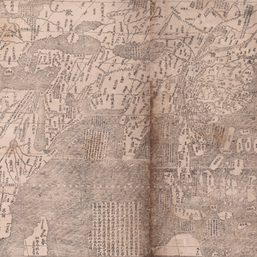
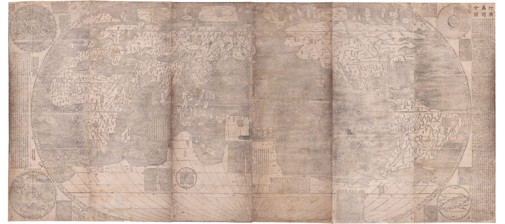
A Complete Map of the Ten Thousand Countries of the World
When Matteo Ricci (1552–1610) settled in southern China in 1583, he displayed a European world map on the wall of his house.
After visitors asked for a translation, he and Chinese colleagues produced a series of increasingly larger maps, including the six-panel woodblock-printed version made in 1602. The map on display at the museum is one of only six complete copies in existence, and it is the oldest surviving Chinese map to show the Americas.
The depiction of the world is based upon European models, but the mode of production (woodblock print), original format (screen or scrolls) and heavy annotation are hallmarks of Chinese tradition. Unlike European maps, which place the Atlantic Ocean at the center, Ricci has put the Americas on the right and Eurasia and Africa on the left, placing China and the Pacific Ocean at the center.
A Chinese tradition of densely annotating maps is evident in the text that covers the map, in some places supplying place names, and in others a remarkable depth of information about the geography of the world and the customs of people and animals in it. The map also contains imaginative descriptions of peoples at the peripheries of the world as known to China and Europe in the 17th century.
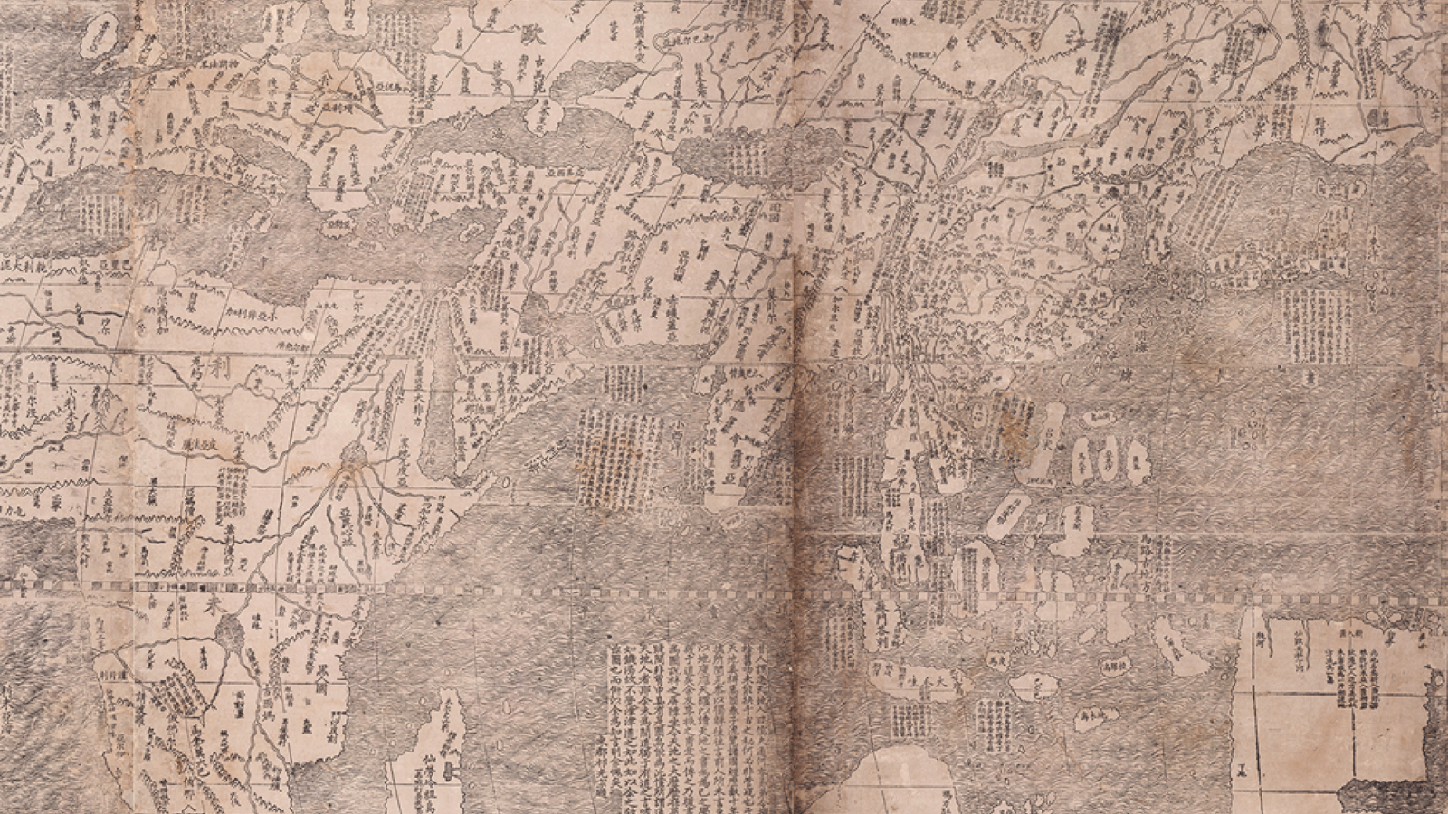
The 1674 Verbiest Map
A Complete Map of the World
Sea creatures cavort in the waves, a six-masted trading vessel sails the Atlantic, and exotic animals populate the southern continent in this monumental eight-panel map.
The world is displayed in two hemispheres, reversing the conventional European positioning so that China and the Pacific are toward the center, with the prime meridian (where the longitude is 0°) running through Beijing.
Made by the Flemish priest Ferdinand Verbiest (1623–1688) with the help of Chinese collaborators, the map is one of the largest woodblock-printed maps of its type. Verbiest arrived in China after the Ming dynasty had fallen to the Manchu-ruled Qing dynasty. Highly skilled in many disciplines, he became a court adviser, working especially closely with the Kangxi emperor. This ruler was astute in using the service of Jesuit missionaries in ways that furthered his own political power and he enlisted Verbiest’s aid with astronomical predictions, calendrical studies and ballistics.
The Spread of Knowledge
Although Europe and China had contacts via overland routes from the first century CE, records of these interactions are few. Many Europeans learned about China from Marco Polo’s accounts of his time there in the late 1200s.
After ending its journeys of sea exploration in the early 1400s and abandoning trade via the Silk Road, China’s contacts with the West became very limited for almost two centuries, until the early 1600s.
The maps in this exhibition are the product of collaborations between European Jesuit missionaries and Chinese scholars in the 17th century. They combine Chinese knowledge of Asia with European understandings of other parts of the world, which European powers first began to explore through long sea journeys in the 15th century.
Like people everywhere, the Chinese have had a long interest in mapping the lands around them. Although from an early date Chinese mapmakers drew scaled and measured representations of terrain and had an understanding of the spherical Earth, these ideas were not sustained. The idea of the spherical Earth was no longer well known by the 17th century, and Chinese world maps tended to represent the earth as square, China as predominant, and other countries squeezed into the margins. Radical ideas were introduced to Ming-dynasty China with European maps: The world was spherical, had more water than land, and contained five large continents.
Jesuits in China
The objective of the Jesuits in China was to spread Christianity. But when missionaries arrived in the late 16th century, they encountered a people who believed in the superiority of Chinese civilization and felt the “barbarians” outside their borders had little to offer.
Chinese scholars, however, soon became deeply interested in European sciences, especially astronomy. And it was through astronomy that the Jesuits (many of whom were highly skilled scientists) began to gain the trust of the Chinese elite and eventually became advisers to the imperial courts. The priests accommodated themselves to Chinese culture by learning the language, wearing local clothing and trying to find connections between Confucian beliefs and Christianity.
In Chinese society, the emperor was the mediator between earth and heaven, and much of the scheduling of public life was predicated on the calendars issued in his name. These calendars were calibrated by precise observations of the sun, moon and stars. By demonstrating the advantages of European astronomical predictions (of eclipses, for example), the Jesuits were able to convince the Chinese that European ideas could be valuable. The Chinese were also fascinated by the things the Jesuits brought with them, including clocks, prisms and world maps.
Despite the Jesuits’ significant tenure in China, Christianity was never adopted there on a large scale. But the long association between scholars from East and West led to the transmission of knowledge in both directions and sparked cross-cultural curiosity that continues today.
Interactive Displays
The museum has partnered with Ideum, a pioneer in the use of interactive computer-based experiences, to create two vibrant 55-inch digital displays that allow visitors to delve deeper into the Ricci and Verbiest maps.
It’s a first for both the maps and the museum. While the museum regularly engages visitors through interactive elements, displays of this size and scope have never been developed. And this will also be the first time these maps, which have had very limited public exposure, will be accompanied by an interpretive element that allows visitors to explore their content so fully.
The most important resource the displays offer is access to extensive translations of the maps’ detailed annotations, which are written in classical Chinese. A traditional element of maps made during this time, these annotations provide intriguing details about distant lands and the people and creatures mapmakers believed inhabited them. The digital displays allow multiple users to zoom in on areas of interest and read a translation of the text in English, in some cases supplemented with curator commentary. For many visitors, the meaning of the map’s Chinese annotations would otherwise be missed entirely.
“This text is just fascinating,” says Natasha Reichle, associate curator for Southeast Asian art and a curator of the exhibition. “You get a real sense of how much the mapmakers knew about the world, and of their curiosity and wonder. At that time, maps like these were not so much tools to get somewhere but objects for your mind to explore.”
The interactive display will also feature related images, such as German artist Albrecht Dürer’s famous 1515 print of a rhinoceros, which mapmakers would have relied upon to develop their own depiction of this exotic animal, having never seen one in person. These supplementary materials provide context about the world in which these maps were made, and the kinds of resources Ricci and Verbiest had at their disposal.
Pairing the maps with a touch-screen experience was a natural fit, and a great opportunity to implement technology that museum staff had long been eager to try out, says Lorraine Goodwin, interpretive media specialist, who managed the project.
“It’s the perfect application of this technology because it really brings the content to life,” Goodwin says.
Main image: A Complete Map of the Ten Thousand Countries of the World, 1602, by Matteo Ricci (Italian, 1552–1610), with Li Zhizao (Chinese, 1565–1630), printed by Zhang Wentao (Chinese, dates unknown). China; Beijing. Six-panel woodblock print; ink on paper. Owned by the James Ford Bell Trust, held at the James Ford Bell Library, University of Minnesota.
Organizers & Supporters
China at the Center: Rare Ricci and Verbiest World Maps is organized by the Asian Art Museum in partnership with the University of San Francisco. Presentation is made possible with the generous support of The Akiko Yamazaki and Jerry Yang Fund for Excellence in Exhibitions and Presentations, James Ford Bell Trust, Penelope L. Wong and S. Timothy Kochis, and Maura and Robert Morey.
Manage Consent
To provide the best experiences, we use technologies like cookies to store and/or access device information. Consenting to these technologies will allow us to process data such as browsing behavior or unique IDs on this site. Not consenting or withdrawing consent, may adversely affect certain features and functions.
Functional
Always active
The technical storage or access is strictly necessary for the legitimate purpose of enabling the use of a specific service explicitly requested by the subscriber or user, or for the sole purpose of carrying out the transmission of a communication over an electronic communications network.
Preferences
The technical storage or access is necessary for the legitimate purpose of storing preferences that are not requested by the subscriber or user.
Statistics
The technical storage or access that is used exclusively for statistical purposes.The technical storage or access that is used exclusively for anonymous statistical purposes. Without a subpoena, voluntary compliance on the part of your Internet Service Provider, or additional records from a third party, information stored or retrieved for this purpose alone cannot usually be used to identify you.
Marketing
The technical storage or access is required to create user profiles to send advertising, or to track the user on a website or across several websites for similar marketing purposes.